 freemapper
9. Printing at the right scale at home and in a copy shop
An orienteering map must have the scale printed on it. The PDF from freemapper-print has it exactly: 1 mm on the paper is the ground distance the print scale sets. Whether the printout keeps it is decided in the print dialog.
Creating the PDF
For an event, export writes the PDFs (chapter 5). For a quick print of the bare map without a project file there is render:
freemapper-print render rummelsburg.omap --out rummelsburg-4000-a4.pdf --paper a4
Without --scale the program prints at the scale of the map. --scale 3000 prints at 1:3000. Choose A4 or A3 (--paper) and, if needed, the orientation (--orientation). With auto the program takes the orientation that cuts off less of the map. render leaves 5 mm free on every side and prints neither title nor scale check bar. It does print the footer: the copyright lines from the map notes and the credit line, in the program language, on a white box in the bottom-left corner of the printable area. The 5 mm margin is too narrow for them below the map. If the box covers part of the map, render says so; a project with a wider passe-partout puts the footer below the map. First the program writes a line with the paper, the print scale and the factors, then come notes and a reminder to print at actual size.
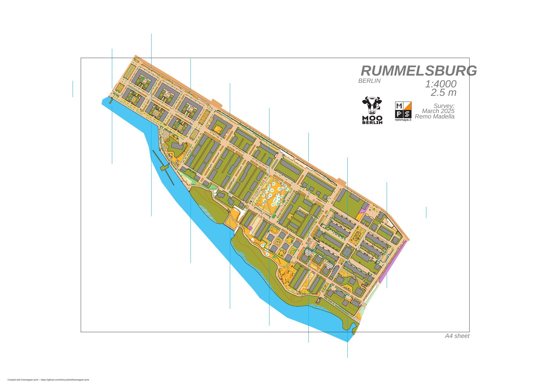
Output of render for the Rummelsburg map: A3 landscape at 1:4000, the whole map on one page. Map: Remo Madella, MOO Challenge Berlin 2025.
A course sheet comes from export too (chapter 8). It has the same scale rules as a layout sheet. A course sheet shows the map in the map frame, with the course overprint in purple over it, the description box and the sheet elements. If the course has a mask for window or corridor orienteering (chapter 11), the paper stays white in the masked area; the program still prints the overprint, the description box, the title, the scale check bar and the footer in full. Printing works the same. In a PDF from --single-file, each page has the paper of its own layout, and the print dialog must print every page at actual size.
Printing at actual size
Open the PDF and choose 100 % or "Actual size" in the print dialog. Switch off "Fit to page" and "Shrink to printable area". Any other setting changes the scale, and the map is no longer right. In a copy shop, say the same: no scaling, 100 %, paper as in the PDF.
A4 or A3
If the map is larger than the map frame (for render, the page less 5 mm on each side), the program cuts it off and tells you, for example:
Warning: the map does not fit on the page. It is 4.0 mm too tall for the printable area. Try A3 paper, or ...
The number says by how many millimetres the map extends beyond it, both sides together. It is measured on what would actually print, with line widths, point symbols and texts. The map is not shrunk, because that would falsify the scale. You can take larger paper (A3), a print scale with a larger number, or in a layout choose the part of the map with centre_map_mm and mark the cut as intended with map_frame.crop = true (chapter 6). If you chose the orientation yourself, the message also names the other one. The PDF is written even with an overflow, so you can see what is missing.
How large the symbols are
The specification for the map kind sets the symbol sizes for a base scale: 1:4000 for sprint maps (ISSprOM), 1:15000 for forest maps (ISOM). A larger print enlarges everything by the same ratio, the terrain and every symbol. A sprint map at 1:3000, which the standard recommends for the youngest age groups, has its symbols at 133 %: a small footpath is 0.36 mm wide instead of 0.27 mm. A forest map grows to 150 % at 1:10000, 200 % at 1:7500 and 300 % at 1:5000. The map needs correspondingly more paper.
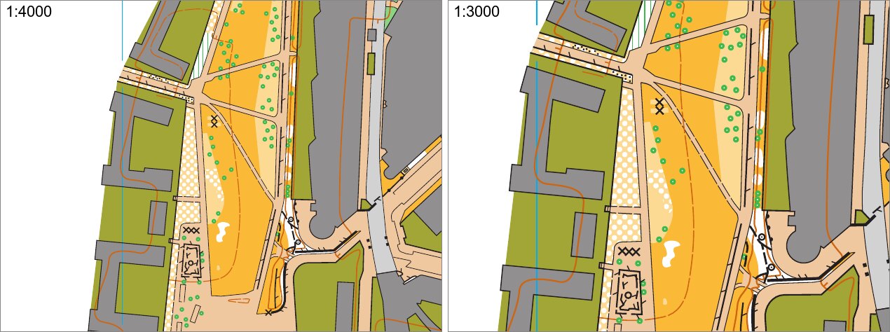
The same spot on the map at 1:4000 (left) and 1:3000 (right), each 80 mm × 60 mm from an A4 sheet at actual size. Map: Remo Madella, MOO Challenge Berlin 2025.
The standards foresee no print smaller than the base scale. The program prints it anyway, for example a sprint map at 1:5000. The symbols then keep their 1:4000 size and only the terrain shrinks. The program warns:
Warning: 1:5000 is not a standard scale for sprint maps. The map is reduced and the symbols keep their 1:4000
size. Use this print for training only.
For this the program needs the map kind (sprint, schoolyard, forest). render tells it from freemapper.toml or from the map file, or you give it with --kind. In a project it is map.kind.
Checking the scale with a ruler
A layout shows a scale check bar when it has a scale_check_bar element (chapter 7). init adds one, and check reports a layout without it. Put the ruler on the bar: with "200 m = 50 mm" it must be exactly 50 mm long. render prints no bar. Then measure between two points whose distance you know, such as two building corners or the ends of a straight stretch of street. For 100 m your ruler should show:
| Print scale | 100 m on the map |
|---|---|
| 1:4000 | 25 mm |
| 1:3000 | 33.3 mm |
If the value is off, the printer has scaled. Check the print dialog. The examples examples/gleisdreieck-scales and examples/rummelsburg-competition-layouts each show one map at 1:4000 on A4 and at 1:3000 on A3.
Notes about printing the map
These notes come from render, check and export:
- "not drawn because the symbol is unknown or hidden": objects whose symbol the map file hides or does not know. They are missing in the PDF.
- "simplified or cut short": an object needs more drawing work than the program allows per object. It appears simplified or cut off.
- "not drawn because the page reached its drawing limit": the whole page needs more drawing work than the program allows per page. Only broken or deliberately overloaded files get there.
- "not drawn because the program does not know their object type": the file holds objects of a kind OOM does not write. They are missing in the PDF.
- "drawn without an area pattern whose spacing is below 0.05 mm or not a number": the map file asks for an area pattern denser than 0.05 mm or with invalid numbers. The program leaves the pattern out and prints the rest of the area.
- "Note: ... The map kind comes from the map file instead.": the
freemapper.tomlnext to the map is broken. The program then takes the map kind from the map file. A map kind the program does not know is no error: the map file decides then too, without a note. - "the font Arimo replaces ...": the PDF contains only the Arimo font. The program replaces the other fonts of the map with it.
- "the embedded font has no glyph for these characters, so they are missing in the PDF": a character of the map is not in Arimo and is not printed.
- "the footer with the copyright and credit lines sits on a white box … and covers part of the map" (
renderonly): the footer lies on the map in the bottom-left corner. Use a project to put it below the map. renderprints freemapper's information block (title, scale, scale bar, credits) only with--show-sheet-objects. At another print scale it scales with the map, so a scale printed in it can be wrong. North lines belong to the map and are always in the PDF.