 freemapper
6. Choosing the map area in the browser
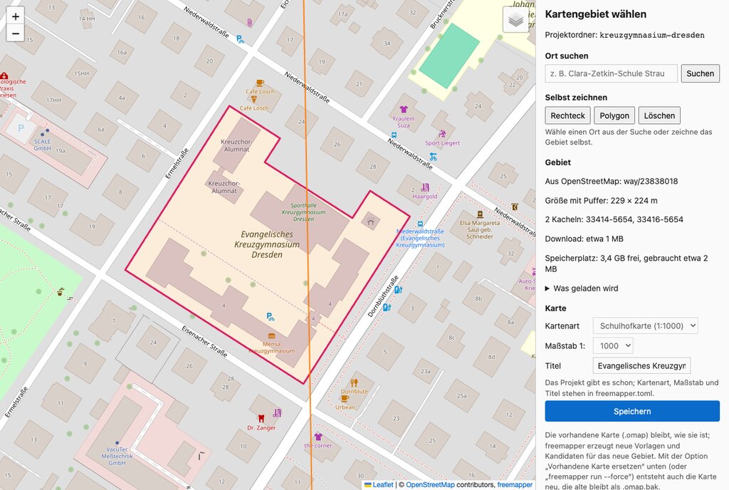
The area selection with the Kreuzgymnasium Dresden (German interface). Map data © OpenStreetMap contributors.
- Search a place: type a name, e.g. "Kreuzgymnasium Dresden", and pick a result with an area.
- Draw it yourself:
- Rectangle: click two corners.
- Polygon: click the corners one by one. To close it, click the first corner or double-click.
- Esc cancels, Backspace removes the last corner.
- Background: at the top right, choose OpenStreetMap or the aerial photo of a state. The list names every supported state with its agency, for example "Aerial photo Brandenburg/Berlin (LGB)" or "Aerial photo Saxony (GeoSN)".
- On the right you see:
- the size with buffer;
- the data tiles that will be downloaded (thin lines on the map);
- the estimated download;
- the free disk space and how much of it the download needs. In the list "What is downloaded", anything that does not fit is marked "does not fit on the disk". Above it the page shows the messages from chapter 15 and whether freemapper leaves the part out or stops.
- Set map kind, scale and title, then click Save. After that you can create the map right on the page (next section), or close it with Done and start
freemapper runin a terminal.
The page runs only on your computer. With its buffer, an area may be at most 4 km × 4 km.
Create the map in the browser
Below the settings sits the block "Create the map". It needs no terminal.

The options with the defaults of the example (PDF, cache only, source lines "freemapper only"). The screenshot shows the German page.
Choose the area as above. The button "Create map" stays off while there is no area, the preview is still computing, the area is too large or outside the supported states, or the disk space is not enough (unless "Cache only" is ticked). The line above the button names the reason.
Set the options. They match the switches of
freemapper run:Option on the page Terminal switch Write an OCAD starter project --ocadPrintable PDF --pdfCheck print with every candidate --pdf-candidatesTraining map --trainingScale bar on the PDFs --pdf-scale-barSource lines on the PDFs: automatic, full, freemapper only --pdf-sources auto,full,credit-onlyPermit notes --permits(chapter 12)Cache only, no network --offlineReplace the existing map --forceThe scale bar and the source lines only apply when a PDF is made; without a PDF they are greyed out. "freemapper only" names only freemapper on the PDFs. The data licences (ODbL, dl-de/by-2-0) require attribution when you pass the map on; then you name the sources yourself. The page shows this hint as soon as you choose it. Map kind, scale and title are set further up; for an existing project they are read-only (they live in
freemapper.toml).The section "What goes onto the map" (collapsed) sets the content profile and the exceptions per group, the same as
--contentand--content-set. A group set to "As in the profile" follows the profile. If you change the profile, your exceptions stay and you can reset them one by one. The page saves the choice with the area; what the profiles do is explained in section 8.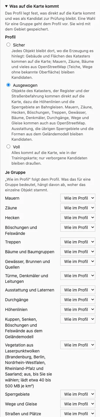
The profile and the groups (German interface). The vegetation from laser point clouds is off until you choose it.
Press "Create map". If the area or the content settings changed since the last save, the page saves them first. "Replace the existing map" appears only when a map exists, and is never ticked in advance. When it is ticked, a dialog asks first; "Cancel" has the focus there. The old map stays in the project folder as
.omap.bak.Progress: The page shows "Step 2 of 4: Computing templates", a bar without a percentage (freemapper does not know the duration), the last eight log lines and the warnings, for example about a second state in the area. The warnings stay after the run. While the run goes on, the area, the settings, "Save" and "Done" are locked. If you reload the page, it shows the running run again.

Progress in the middle of a run (a staged server answer for the picture).
Cancel: "Cancel" stops the run at the next safe point. Whatever is written or downloaded stays whole (no half files); a new run carries on from there.
Map preview: Below the run status the section "Map preview" shows the map objects as an image. After a run, and when you open the page for a project that has a map, it is the map as generated last. If you change the profile or a group in "What goes onto the map", the page shows the effect after a short pause, without a run and without saving; the old image fades while the new one is computed (a few seconds the first time on a large area, about one second after that). The line above the image says what it shows: "As generated last." or "With the settings on this page, not saved yet." "Open full size" opens the image in a new tab. The image shows the map objects only, no candidates, no orthophoto and no legend, and no text. If you changed the area, the map kind or the scale since the map was generated, the page keeps showing the last image and says that a new preview needs a run with "Replace the existing map": a run that keeps the map writes no preview. A drawn area that is not saved yet gets no new image either, and the line says so. During a run the page shows the last image and updates it when the run ends. A later fetch alone does not make the image out of date. Before the first run there is no image ("No map generated yet."). A map from an older freemapper has none either; the page says so, and the next run with "Replace the existing map" makes one.
Result: The page says whether the run finished, failed or was cancelled, lists the files with their size and names the project folder. "Open folder" opens it in the file manager; if that fails, the path is shown as text. If a map existed and "Replace the existing map" was off, it stays as it is, and the page says so. On an error the program's message is shown; "Create again" starts a new run.
One folder, one run. While a run goes on, the project folder holds the file .freemapper-run.lock. A second run, from the terminal, from an AI assistant or from a second browser window, stops with the message "another freemapper run is using this folder (since …, started by …)". Wait until the first one is done, or cancel it. After a crash the lock counts as abandoned after 60 seconds. If a run of another project is going on, the new one does not start, because the projects share the cache.
Defaults are set when the page starts: freemapper select my-schoolyard --pdf --ocad ticks the two options already. The switches are --ocad, --pdf, --pdf-candidates, --training, --pdf-scale-bar, --pdf-sources auto|full|credit-only and --offline; the AI assistant can pass the same fields to open_area_selector. Only the AI assistant can preset "Permit notes" (permits); select has no switch for it. "Replace the existing map" has no default.
The page speaks German or English: the language of the program (chapter 15), else that of the browser. It calls no address outside your computer, apart from the background map tiles (through the local server) and the orthophoto services when you switch them on.