 freemapper
8. What the templates show
The examples show the Kreuzgymnasium Dresden. Orthophoto, terrain and surface model: Quelle: GeoSN, dl-de/by-2-0, Daten geändert.
| Template | Picture |
|---|---|
| Orthophoto: top view, 20 cm per pixel. Good for paths, squares and vegetation, but trees hide the ground. | 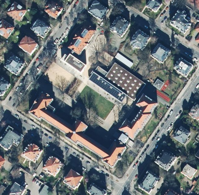 |
| nDSM (height above ground): yellow 0.3–1 m (walls, benches, cars), orange 1–2.5 m (hedges, fences, playground equipment), light green 2.5–8 m (bushes, sheds), dark green above 8 m (trees, houses). Shows what stands, also under trees. | 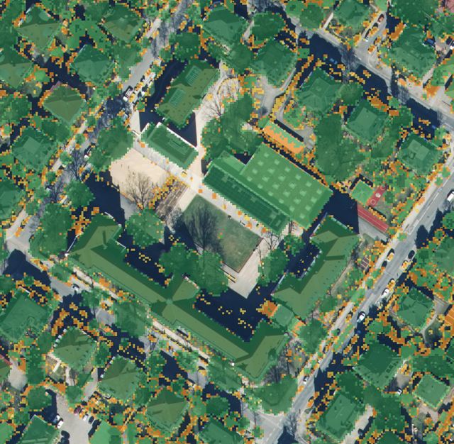 |
| Hillshade: the terrain as if lit from the north-west. Shows banks, hollows and earth walls. | 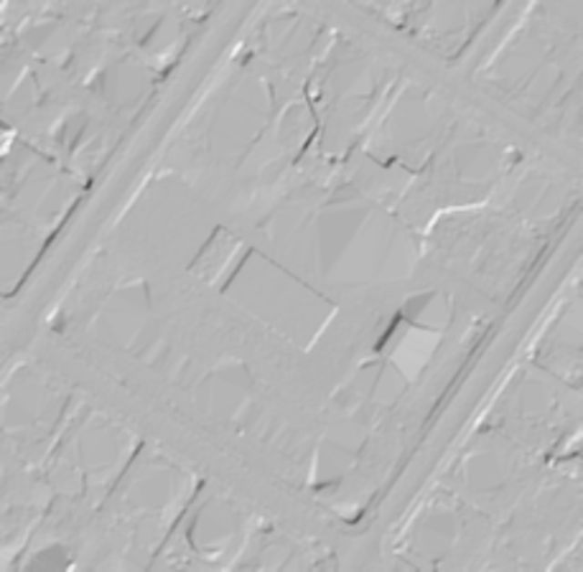 |
| Slope: the darker, the steeper. Helps with banks and stairs. | 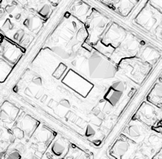 |
| Local relief: the terrain minus its smoothed mean (over about 5 m on sprint maps, 3 m on schoolyard maps, 8 m on forest maps). Light is higher than the surroundings, dark lower; the general fall of the ground is gone. Shows mounds, hollows, banks and ditches that the hillshade hides on a slope. | – |
The candidates map also holds the contours: every 1 m on schoolyard maps, every 2 m on sprint maps, every 5 m, in flat land every 2.5 m or in steep land every 10 m on forest maps (Forest maps), every fifth one an index contour. They are computed from the terrain model and smoothed. For the map they are a draft, not a finished result.
From the terrain model come further candidates the contours miss:
- Small knolls (109) and small elongated knolls (110): a mound at least 1 m high on sprint maps (0.5 m on schoolyard maps), narrower than 5 mm on paper and at least 10 m, that rises clearly from its foot. An elongated knoll is turned along its length.
- Small depressions (111): the same, as a hollow.
- Earth banks (104) and, from 3 m high, impassable cliffs (201): a narrow, steep strip that takes most of its height difference within a few metres. A plain slope does not count. The ticks point down.
None come at buildings, in water, or next to walls, fences and banks that are already drawn; a bank is left out only when most of it lies at a building. Knolls and depressions do not come on residential, mixed, commercial and traffic land or in allotments, where they are mostly heaps, garden mounds, courtyards or ramps; depressions not within 8 m of a building either. A cliff along a street or a building is mostly a retaining wall and is offered as an impassable wall (515). A bent or kinked step is split into pieces that follow it. The terrain model has one height per metre, so it misses walls narrower than about a metre and shows road embankments as banks. Check each one in the terrain. A bank may turn out to be a wall, a cliff a staircase. Everything from the terrain model belongs to the group landforms (see below), banks, cliffs and retaining walls too: with full or --content-set landforms=map they go straight onto the map. slopes=map takes only the banks of ALKIS and OpenStreetMap, in Bavaria also the earth walls, rocks and cave entrances of the landscape model.
Vegetation from laser point clouds
In Brandenburg, Berlin, North Rhine-Westphalia, Rhineland-Palatinate, Saarland and Bavaria freemapper can derive the vegetation from the classified laser point clouds of LGB, the Geoportal Berlin, Geobasis NRW, LVermGeo RP, LVGL and the Bayerische Vermessungsverwaltung: open land (401), runnable forest (405), the green shades 406, 408 and 410, and undergrowth (407, 409). It counts in every 3 m cell how many laser returns reach the ground and how many stay at the heights that slow a runner. That shows more than the nDSM, which only sees the crowns. The green shades follow the layer a runner moves through: of all returns below 3 m, the share that lies between 0.8 and 3 m. From 20 % a cell is 406, from 35 % 408, from 50 % 410 (ADR 0138). The crowns above do not count. The outlines are traced on a raster three times finer and slightly blurred, so that they follow the edge of the vegetation instead of the 3 m steps of the cells (ADR 0136).
The group vegetation is off in every profile, full included, because the point clouds are large. Per square kilometre tile freemapper loads about 160 MB in Brandenburg, about 240 MB in Berlin (about 100 MB as LAZ in the cache), mostly 50 to 165 MB in North Rhine-Westphalia, mostly 110 to 500 MB in Rhineland-Palatinate, about 40 MB in Saarland and mostly 100 to 600 MB in Bavaria; a park usually needs two to four tiles. Only --content-set vegetation=candidates (or the area page) makes the next fetch load them into the shared cache. derive writes data/vegetation.geojson from them, and the export puts the areas into the candidates map. There are none at buildings, in water or on paved areas; roofs that ALKIS no longer has are recognised by their laser echoes too. Where the map already has a park or a wood from ALKIS, the candidate shows only the part of another class.
It is checked on Sanssouci, the Volksgarten in Cologne, the Stadtpark in Mainz, the Viktoriapark in Berlin and the old town of Saarlouis. Reeds and shrubs at a shore come out as 410. Every flight the six states publish was made without leaves, between December and March, and the green shades are set on such flights. On the Schmausenbuck in the Nürnberger Reichswald (flown on 20 December 2021) they were measured against the canopy height of the summer pictures: 71 % of the thickets come out green and 7 % of the tall forest. Young pole stands, with crowns at 3 to 8 m and a clear stem space, stay runnable forest (405). LVGL thinned the Saarland point cloud to one point per 0.5 m; freemapper still finds the crowns there, but the green shades come in scattered patches. When the Geoportal Berlin changes an archive, freemapper loads its tiles again. The date on the Bavarian candidates is the day of the flight, which freemapper reads from the laser points (20 December 2021 on the Schmausenbuck). Older flights do not name it; there it is the day the file was made. When tiles of different days lie under a map, the candidates carry the oldest, in every state. The point cloud can be some years older than the orthophoto. Check the areas against the orthophoto and in the terrain. When space is short, the point clouds are the first part left out. The other states have no point-cloud source yet. Saxony took its point clouds off its download area in November 2026.
What goes straight onto the map
Not everything freemapper finds is equally reliable. What was surveyed officially (ALKIS, the Berlin registers) goes straight onto the map. What is guessed from OpenStreetMap, the street survey or the terrain stays a candidate and appears only in the template. You set how this is divided before the map is made:
| Profile | Effect |
|---|---|
safe | Every object stays where the build puts it: buildings, ALKIS areas (traffic, water, parks) and OSM paths with a known surface go onto the map. Walls, fences, trees, OSM ponds, paths without a known surface and everything else uncertain stay candidates. |
balanced (default) | The objects of the cadastre, the registers and the street survey go onto the map: streets and squares with kerbs and green strips. Stairs, walls, fences, hedges, water, trees, tree groups, paths, railways, banks, passages, monuments, towers and above-ground pipelines also come from OpenStreetMap, which is often the only source there. The contours go onto the map too. The areas that shall not be entered along railway tracks go onto the map (and the points in them go); other such areas, which rest on a guess, street furniture and lamps, OSM parks, and the knolls, depressions, banks and cliffs from the terrain model stay candidates. For pipelines (528, 529) the norm requires the symbol to be explained in the legend; writing it is the mapper's job. |
full | Everything goes onto the map, as on the check print. |
Single groups can differ: walls, fences, hedges, slopes, stairs, trees, water-features, monuments, furniture, passages, contours, landforms, vegetation, out-of-bounds, paths, streets, each map, candidates or off. vegetation is always off without a choice of its own (see above).
freemapper run <folder> --content balanced --content-set fences=candidates --content-set contours=map
The choice is stored in the project, in freemapper.toml:
[content]
profile = "balanced"
fences = "candidates"
contours = "map"
init, export and run take --content and --content-set; an assistant through MCP sets content and content_set on create_project and start_pipeline. A new --content replaces earlier exceptions, --content-set alone adds to them. You see the result after export --force.